Channel Reorganization
July 1, 2020
Tonight we set to the task of reorganizing the channels on the Discord instance. We now have 45 channels, down from 90+ channels. A few more channels are likely to go away but it should make it far, far easier for people to find the right channel to post something, as it was a common sight to see people get overwhelmed and confused when signing on to the Discord for the first time.
Many great thanks go to everyone in the #cartography (nee #feedback-and-suggestions) channel who assisted with this.
The Areas
We settled on the following layout after going through a few iterations over a few weeks.
These are not set in stone and they are meant to be zones of focus —rather than meaningful regions— and you should post to whichever channel seem most relevant for your immediate concerns. They also don’t have hard edges to help with cross-posting across areas.
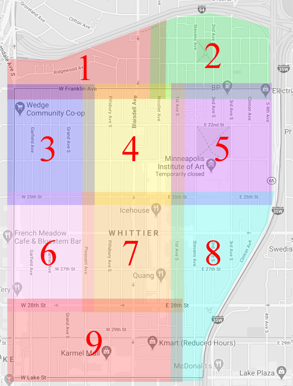
Zone 1: Loring Heights
Technically part of the Loring Park neighborhood but a few people have found themselves in our Discord instance. Boundaries are:
- North: I-94
- East: Nicollet Avenue South
- South: West Franklin Avenue
- West: Lyndale Avenue South
Zone 2: Stevens Square
Same as with Loring Park, quite a few neighbors have found themselves in the Discord instance. Boundaries are:
- North: I-94
- East: I-35W
- South: West Franklin Avenue
- West: Blaisdell Avenue South
Zone 3: The Wedge
Just like the name says, the main feature of this area is The Wedge Co-op and its (in)famous parking lot. Boundaries are:
- North: West Franklin Avenue
- East: Pleasant Avenue South
- South: West 25th Street
- West: Lyndale Avenue South
Zone 4: Blaisdell North
Largely a residential area, boundaries are:
- North: West Franklin Avenue
- East: 1st Avenue South
- South: 25th Street
- West: Pleasant Avenue South
Zone 5: Washburn Fair Oaks
With the Washburn Fair Oaks park right in the center of it, it also contains the MIA. Boundaries are:
- North: West Franklin Avenue
- East: I-35W
- South: E 25th Street
- West: Nicollet Avenue South
Zone 6: Whittier Park
The main features are Whittier Park (where people first started getting organized) and Whittier International Elementary School. Boundaries are:
- North: West 25th Street
- East: Pleasant Avenue South
- South: West 28th Street
- West: Lyndale Avenue South
Zone 7: Eat Street
Comprising most of the business corridor on the south end of Nicollet Avenue, its boundaries are:
- North: 25th Street
- East: 1st Avenue South
- South: 28th Street
- West: Pleasant Avenue South
Zone 8: MCAD
Comprising MCAD, its student apartments, and everything south of it until reaching Lake St, its boundaries are:
- North: East 25th Street
- East: I-35W
- South: East Lake Street
- West: 1st Avenue South
Zone 9: Karmel Lake
This area encompasses most of the commercial and businesses along Lake Street, including Karmel Mall, and the now emptied K-Mart that cut Nicollet Avenue in half. Boundaries are:
- North: 28th Street
- East: 1st Avenue South
- South: Lake Street
- West: Lyndale Avenue S
Again, the boundaries are malleable so if something happens on say, Lyndale Ave & 25th St, it could be posted to both areas 3 and 6.
In addition to these areas, which each have their own category, there are two extra ones:
- 0: Area Primary Contact. This is meant for the area leads to chat and organize the neighborhood watch should it become necessary again. Neighborhood wide emergencies also go here.
- 10: Adjacent Neighborhoods. Just like the name says, this is a category with channels for people around Whittier itself.
If you have questions or issues, make sure to let us know in the #feedback-and-suggestions channel.
Posted In: Discord